
Cap de Fibló in Formentera

Formentera, July 8, 2026
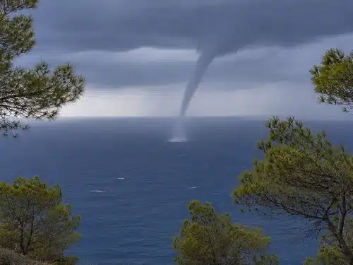
Have you ever seen a funnel cloud descending from a storm over the sea around Formentera? At first glance, it may look like a tornado, but in the waters surrounding the Pityusic Islands, this striking phenomenon is known as a Cap de Fibló. It is one of the most spectacular sights the Mediterranean can offer when the atmospheric conditions are just right.
Although many people mistake them for tornadoes, these funnel clouds do not always develop into waterspouts. Whether they do depends on a combination of atmospheric factors that determine whether the vortex eventually reaches the sea surface.
An exceptionally warm Mediterranean combined with an intrusion of cold air at higher altitudes creates the perfect environment for these phenomena to develop, particularly in the waters surrounding Ibiza and Formentera. The typical weather patterns of late summer encourage the growth of thunderstorms capable of producing these spectacular funnels.
Beyond its meteorological significance, the Cap de Fibló is part of the cultural heritage of the Balearic Islands. Its name, inherited from the traditional vocabulary of local sailors, is still used today to describe one of the Mediterranean autumn’s most distinctive weather phenomena.

A Cap de Fibló is the funnel cloud that descends from the base of a thunderstorm cloud, usually a cumulonimbus. Its distinctive elongated, cone-shaped appearance makes it easy to spot on the horizon, especially when it forms over the sea.
The origin of its name is rooted in traditional Balearic vocabulary. Historically, a fibló refers to the sting of a bee or wasp. The resemblance between that pointed shape and the funnel hanging from the cloud led sailors to adopt the term centuries ago.
Over time, the meaning of the word expanded and it also came to refer to waterspouts. As a result, in Ibiza and Formentera the term fibló is commonly used when talking about waterspouts, while Cap de Fibló specifically refers to the funnel cloud itself.
From a meteorological perspective, not every Cap de Fibló develops into a waterspout. Many disappear just a few minutes after forming, before the vortex ever reaches the sea surface.


The waters surrounding the Pityusic Islands offer an especially favourable combination of conditions for the development of waterspouts during late summer and early autumn.
The Mediterranean retains much of the heat accumulated during the sunniest months of the year, providing a huge amount of energy to the atmosphere. When colder air masses move in at higher levels, the resulting temperature contrast significantly increases atmospheric instability.
This imbalance encourages the development of towering storm clouds with powerful updrafts capable of organising the rotation of the air. In addition, Formentera’s marine environment allows many thunderstorms to develop entirely over the sea before approaching the coast. As a result, it is relatively common to see funnel clouds from land that never actually affect the islands.
Although waterspouts can occur at any time of year when conditions are favourable, the peak season runs from late August through October.
September usually offers the most favourable conditions thanks to the exceptionally warm sea and the arrival of the first periods of atmospheric instability typical of the Mediterranean autumn. In some years, isolated events may even occur during November, when sea temperatures remain higher than average.
Low-pressure systems and, at times, DANAs (isolated upper-level depressions) further increase atmospheric instability by bringing cold air aloft over a still very warm sea, making the development of intense thunderstorms more likely.

The visible funnel cloud does not always mark the beginning of the phenomenon. In many cases, rotation begins earlier at the sea surface, where the wind lifts spray and foam while the funnel remains separated from the water.
Only when the two appear to connect visually does the classic image of a waterspout emerge, although meteorologists consider the phenomenon to have already been active moments earlier.
The opposite can also happen. Many Cap de Fibló funnels dissipate before completing that connection and never develop into fully formed waterspouts.
If the vortex reaches land while maintaining its circulation, it is no longer classified as a waterspout but as a tornado.
Every season, Cap de Fibló funnels create breathtaking scenes over the waters of Formentera and Ibiza, making them one of the Mediterranean autumn’s most photographed weather phenomena.
However, these events also pose risks to navigation. Although most remain offshore and are of moderate intensity, they can generate powerful wind gusts, rough seas and sudden changes in sea conditions.
For this reason, it is always advisable to exercise caution whenever these phenomena develop, especially if you find yourself too close to them.

I’m Ramón Tur, the person behind everything written and photographed on this website about Formentera. I discovered the island in 1972 when my parents, aboard the mythical Joven Dolores, took me on vacation from Ibiza for the first time, and it was love at first sight that has only grown stronger over time, making Formentera my place of residence for many years now. If you wish, you can follow me on Instagram @4mentera.com_
If you're planning to visit Formentera, make sure to check out our discount codes section first.

Todos los derechos reservados Pitiusas Market, S.L.U.


